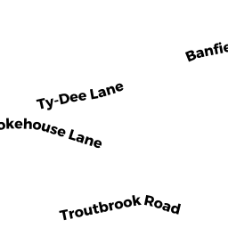
143 TROUT BROOK ROAD, COTUIT
Owner Information
LOW, SAMANTHA J
143 TROUT BROOK ROAD
COTUIT, MA 02635


Property Details
143 TROUT BROOK ROAD, COTUIT is classified as a Single Family Residential (Cape cod).
The primary structure on this property was built in 1990. There are 2,886ft2 of built area within this property. There is 1,346ft2 of residential/living space within this property. This property is listed as having 4 rooms.
143 TROUT BROOK ROAD, COTUIT is valued at $393,900. The land is valued at $148,000 and the structures are valued at $219,900. There is an additional valuation of $26,000 on this property.
This property is in Zone RF. Confirm with local Zoning Board authorities to ensure there are no overlays or other easements on this property.
The most recent deed for 143 TROUT BROOK ROAD, COTUIT is recorded at the local registrar in Book 31926, Page 0202. 143 TROUT BROOK ROAD, COTUIT was last sold on Tuesday, April 2, 2019 for $0.
Assessment data from fiscal year 2022.
Flood Data
According to the FEMA National Flood Hazard Layer, this property does not appear to be in a flood zone. It may also be in an area not yet reviewed. Nonetheless, confirm this information prior to taking any action.
To view the flood hazards around this property, create a FEMA "Firmette" Map of the area around 143 TROUT BROOK ROAD, COTUIT.
Broadband Internet Providers
| Provider | Type | Bandwidth (mbps) | |
|---|---|---|---|
| Comcast | Cable | 1000 | 35 |
| Viasat Inc | Satellite | 35 | 3 |
| GCI Communication Corp. | Satellite | 0 | 0 |
| T-Mobile | Fixed Wireless | 25 | 3 |
| VSAT Systems, LLC. | Satellite | 2 | 1 |
| Verizon New England Inc. | DSL | 5 | 0 |
| HughesNet | Satellite | 25 | 3 |
Broadband service provider data from December 2020.
Adjacent Properties
- 159 TROUT BROOK ROAD, COTUIT
Single Family Residential owned by TODD, ROBERT E JR & SHARPE, MICHELLE - 89 TROUT BROOK ROAD, COTUIT
Single Family Residential owned by MCKENNA, MARY E - 101 TROUT BROOK ROAD, COTUIT
Single Family Residential owned by COLEMAN, MATTHEW & SCHNEIDMAN, ANNE - 123 TROUT BROOK ROAD, COTUIT
Single Family Residential owned by MILKS, JOHN K - 25 FURLONG WAY, COTUIT
Single Family Residential owned by BOURGEOIS, JOYCE T TR